24:23


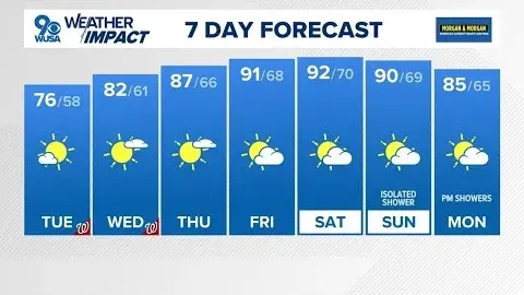
Let's talk more about our forecast now. And a hat tip to our videographer Joe Gurui for this drone video. He was over Reynolds Channel in Leo Beach. Just really picture perfect. We love the tri-state area in this time of year. Meteorologist Scott Padet is here now with another look at our forecast. Scott, we want to bottle this up and then be able to open it up and when it's gets more humid, more hot for us. And that's going to happen the next few days there, KJ. I can already smell the sunscreen of everyone wanting to head to the beach. Look at this beautiful blue sky as you're stepping on out of the door for you right now. Our temperatures, well, they're in the upper 70s. What to
expect? Feeling like summer the next couple of days. 90s for many by Friday and Saturday. So, keep that in mind. It's going to be a bit humid, but not that oppressive heat. Not that heat where you just stick to almost every surface when you're sitting down. Thunderstorm threat, yeah, mainly on Sunday. Back into the forecast for us right now. 78, sunny skies, and look at that, the due point of 43. That's the measure of moisture in the atmosphere. That's low. Our humidity just 29%. So fantastic for us. Right now we're at 82 in Newark, 86 in the Bronx, seeing 71 in Sheep's Head Bay. As we widen out the view, a little bit cooler along parts of Long Island, low 80s in Scarsdale, seeing 84 in Summit to 82 in Somerville.
So all in all, a nice day for us today. Now the next few hours as you're heading on out, lots of sunshine by 7. By 9, yeah, clear skies, temperatures low 70s. As we go into the overnight time frame, we'll see temperatures continue to cool their way down to the mid60s. Uh so we're going about 63 in the city for tonight. Clear and mild. Suburbs will be in the 50s. So another cool start and then a warmer day on the way with our winds out of the southwest and switching west 5 to 10. Now tomorrow it's that taste of summer. We're up to 85° sunny and warm. So remember the average high this time of the year is 76. We'll be about 10° warmer than that yesterday. But this high pressure that I showed
you, it is in charge for us. So, a good deal of sunshine, generally dry. That low humidity at least through Friday changes then as we go into Saturday and Sunday. And because of that, also a better chance of rain on the way. Saturday, 20% chance mainly late Saturday. Sunday's your more of a kind of wash out day for you. On top of that, we have this ridge of high pressure that's keeping that warm air in place. Then breaks down as we go into Sunday. You see this dip right there in the jetream. That's a trough of low pressure. So, as that moves in, we're going to be dealing with the rain moving its way through and cooler temperatures. So, here's the rain that I'm talking about on Sunday. Scattered showers
around, but then by Monday, this forecast model, it's drying us out nicely as we start next week. How much rain can we expect? Not a whole lot. Less than a half of an inch by our long range models. So, we'll take any we can get because we're pretty dry for this time of the year. You see, we're at 90 Saturday, Sunday, 80 for us. And then going into next week, we see 72 degrees as the Knicks are home for us, a cooler breeze, then temps remaining in the low 80s by next Wednesday. AJ, thank you. Scott
Gettsly is free, without subscription fees or ads, and available to everyone. Your support helps us keep the service online, improve its features, and continue providing useful video tools.