41:21


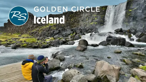
Hey, I'm Rick Steves back with more of the best of Europe. This time we're in Iceland in Rekavik about to head off on perhaps Europe's most epic road trip, Iceland's ring road. Thanks for joining us. From here in downtown Recuik, we'll drive 800 miles all the way around Iceland's ring road. Which highway? Highway one, of course. You can't get lost. Over half the island's population lives in or near the capital, Recuik. It's a fun city with plenty to see and experience, but that's another show. For ring road trippers, this city is the starting and ending point of a week-long adventure. Leaving Recivan sprawl, it's striking how quickly you're immersed in
Iceland's vast and dramatic landscape. We'll experience the majesty of Icelandic nature and its hearty culture. With lots of time on the road and help from Cameron Huitt, my friend and fellow guide book author, we'll see it all. Thundering waterfalls, steaming geothermal fields, bobbing with icebergs, foring glacial rivers, and wandering evocative black sand beaches. quirky fjord side towns and endearing folk culture. We'll chase rainbows, elusive whales, roaming horses, and the cutest puffins. Iceland, about the size of Virginia with just 400,000 people, sits between Greenland and Norway. The ring road links virtually the entire population. From Reyik, we explore the South Coast,
side tripping up Thors Valley, and sailing to the Westman Islands. From Vic, we see glacial lagoons, the rugged East Fjords, geothermal hot zones around Lake Matan, the fishing village of Husik in the far north, and Snifles Nest Peninsula before finishing back where we started. Driving the entire ring road takes about 30 hours non-stop. To do it justice, you need at least five or six days. You can go in either direction. We're going counterclockwise. And it's summertime, so it stays light really late. On the first leg is Iceland's south coast. Just 2 hours from Rakuavic, and we're already deep in the thrills, chalking up the experiences people visiting here dream of.
Cellulent Fos, one of Iceland's most accessible waterfalls, is a favorite stop. The water tumbles more than 200 f feet from cliffs high above like a bridal veil. On sunny days, the scene is like a party as everybody is suddenly waterfall crazy and connoisseurs of rainbows. Late in the day with the setting sun, everyone's a photographer. A slippery trail leads up behind the cascading water. And back here, the energy is palpable. and rain parkas get a good workout. Here in Iceland, we experience both the power of nature and the beauty of nature. The south coast's backdrop is a chain of glaciercapped volcanoes.
This island sits at the rift where the North American and European tectonic plates are slowly pulling apart, resulting in one of our planet's most dramatic and fiery landscapes. This country is expert at monetizing its stunning nature, making the great outdoors accessible. Each morning, rugged vehicles load up with tourists and head for the back country. We've hired one of these enormous trucks with a driver eager for a thrilling experience. We're heading up a remote and rocky valley called Thorsark.
Even in this land of superlatives, Thorsark is one of a kind. Venturing far beyond where normal cars can tread, it's a land of super vehicles. But it's still accessible. There's even a public bus service of this remote valley. All must have tires that deflate with the push of a button for extra traction. Super Jeeps and buses alike, equipped with these monster tires, churn through rivers of glacial melt, giving all on board a tale to tell. People come to hike. Remote lodges provide simple home bases. Up here, nature is a great equalizer as everyone is psyching up, prepping to create that lifetime memory.
Charging deeper and deeper into the valley. I keep thinking the off-road prowess of our vehicle would make for a great TV ad. Finally, we park our super Jeep and actually work up a sweat with a short hike. Feeling small in this primeval setting, we're humbled at the majesty that surrounds us. This is yet another way to be immersed in the raw power of Iceland's nature. Highway 1 laces together a steady parade of sidet options. Each detour comes with a convenient lesson in the local history and a schematic map locating every farm, place to eat or sleep, and point of interest on that smaller road. Like any road
trip, doing the ring road requires multiple one night stays. There are plenty of accommodation options. They range from big boxy hotels to prefab cabins, tight little yurts, remote host, and camping. It's been a long day of sightseeing for us. Time to settle in. Like so many farms, this family is meeting the new demand, housing more tourists and fewer animals. The welcome is warm. I'm Rick Steves. Hello, Mr. Steves. How are you today? I'm good. It's nice to be here. The rooms are simple but plenty comfortable and the views are Icelandic.
A major stop on the Iceland Grand Tour is the Westmin Islands, just a 40-minute ferry crossing from the south coast. While locals sit inside, tourists soak up the view as we approach the craggy group of islands. The ferry squeezes into the harbor and tucked into the shelter of the cliffs, our port comes into view. The Westman Island's only town is a fishing community surrounded by sea cliffs and a rugged terrain shaped by eons of volcanic eruptions. Sightseeing boats are dwarfed and outnumbered by a fleet of fishing boats. Visitors strolling the boardwalk sense how fishing is big in this country, and the Westman Islands fleet is the leading producer.
Main Street has most of the commerce, and it leads past inviting neighborhood lanes to a classic Icelandic church, but the island is best known for a fiery eruption in 1973 when its volcano blew. It was a massive event. The island actually increased in size. The town's volcano museum tells the story. One frightening night, the slumbering volcano above town rumbled violently to life. Everyone evacuated by morning, but for months, molten lava flowed, slowly creeping closer and closer to the town center. The museum centerpiece is an actual house that was completely engulfed by the lava
50 years ago. This was an oozing wall of red-hot molten lava. It was a slow motion disaster gradually consuming the town. Thankfully, it stopped right here. Back at the harbor front, we're catching a minibus tour to get a more personal take on that terrifying eruption and to explore the island. Local guide Abby was born and raised here, knows the island, and is ready to roll. We're driving on lava left from the 1973 eruption. So, you know, good things, bad things with this huge eruption like this.
Now, nobody died because of the eruption, which is a very good thing. We gained also about 20%. The island increased in size about 20%. And you're more famous for tourists. You had the Well, yes, it got us on the map. Also, underneath us are streets. 50 m down. Underneath us, we have streets. We have houses. Actually, not far from here is my grandparents house. And right here below is one of our schools. This marking here is a memorial about a house underneath here from a wealthy fisherman. His house was this house right underneath right underneath us here. And everywhere on this lava we have these wooden crosses uh like this one here for example. Uh this is called Lancata. One of many streets that went under.
So that's the name of a street. There's the main name of the street right underneath us. The townside of the lava ridge has additional examples of what was lost and reminders of how the entire town could have been consumed by the lava flow. The Westman Islands are famous for being the home of many species of seabirds that nest in the grassy ledges and cliffs by the millions. It's particularly well known for its puffins. Ebie takes us to a thriving colony popular with birders and tourists alike. So this location here is the biggest puffin colony in the world. Now people come here to see the puffins. Of
course the puffins they live in the ocean for 8 months and they're only here during the summer just to do that one thing and that is to make that one egg a year that they make. They make one egg per year per couple. Now the half of the colony is right now underneath here. There are thousands of birds sitting taking care of the egg right now underneath us. Right. under us, underneath us, everywhere is a burrow where they've digged in. And they have this like an apartment kind of. And um half of the colony is outside now, out in the ocean getting fish. And um the other half is taking care of the act. And um and people all around the world come to see the pins, of course, and they come here.
Back on the mainland, we're continuing around the ring road, and there's lots more dramatic natural sites. From this rugged promontory, on a clear day, you can see virtually the entire south coast. And just below is one of this volcanic island's many black sand beaches. Travelers are enthralled by this fantastical landscape. Sea stacks rise out of the briney waves. Basalt formations bring out the kid and every adventurer. A windy walk immersed in this pristine beauty can be unforgettable.
Marking the end of the south coast, the village of Vic is the southernmost settlement in Iceland. Vic is both humble and sparse. Little more than a practical pit stop for travelers. And for this village, that's nothing new. Historically, there was no harbor. A century ago, before the arrival of the road, provisions came in by boats beached on this shore. What we've done so far with Cameron Hewitt, who co-authors guide books with me, is all within day tripping distance from Reuik. Recuik is 3 hours that way or 6 days that way. I'm heading straight back to work on the book, but we'll follow Cameron and the crew as he does his research the long way around. We'll meet up back in Reuvic.
Leaving Vic, the traffic thins out and the landscape opens up. We've just left Rick in Vic and now we're continuing around the ring road. And you know, already the terrain is changing and the weather is changing. In fact, Iceland is always changing. That's why it's so important for us to go and travel in person to update our guide books and make sure we have the very latest information. The next stop is glacier country. One/tenth of Iceland is covered in glaciers and the biggest one spreads across the top of these mountains. Its many outlets called tongues reach down and lap at lowland valleys. The road crosses vast plains of glacial grit and gravel laced with milky rivers. At the foot of some glaciers are lagoons
bobbing with small icebergs that have broken off. Lagoon cruises take tourists out on these moody and beautiful waters. Passengers gear up in heavy jackets and prepare for the adventure. They climb into inflatable boats and then float through this dreamy landscape. It's an unforgettable experience no matter the weather. Our enthusiastic guide offers a lesson in glaciers 101. But then, of course, there's still the white ice and the blue ice. After a short explanation of why there are different colors of glacial ice, travelers get a chance to hold a chunk of ice that originally fell as snow 500 years ago. The guide explains how glaciers naturally grow and recede. In fact, this glacier used to extend all
the way across the lagoon at the end of the 19th century, but it's been retreating now for over 130 years. It is absolutely natural, absolutely normal that at some points relations are growing. At some points, the glaciers are retreating. But now the glaciers are retreating way, way faster because of global warming. Even from the shore, people marvel at how glacial ice comes in a stunning variety of shapes, sizes, and colors. The wind pushes the icebergs into a traffic jam where the lagoon meets the Atlantic. Birds and seals feed in the swirling waters as the icebergs wait for their final journey out to sea. When conditions are right, chunks of ice wash
up on the nearby Black Sand Beach. Nicknamed Diamond Beach, it looks like thousands of gigantic gems scattered over Black Velvet. Leaving the glaciers behind, the ring road hugs the wild coastline. The churning North Atlantic surf crashes on deserted beaches and rocky shores. Soon, yawning bays grow narrower, becoming the serene fjords that slice deep into the east coast of Iceland. Driving along the east fjords is long and slow but always scenic and around each bend unfolds one grand fjord after another and you'll come upon a colorful village called Sadis Fjord.
Its majestic setting attracts artists and inspires vibrant murals and trendy places to eat and drink. It's a welcome pocket of quirky creativity in this remote corner of the country. Leaving the fjords and turning inland, the road crosses the vast and arid highlands. Tucked away in these rocky folds is another iconic waterfall. Arriving at what looks like just a desolate volcanic landscape. If you follow the trail, you'll hear the thundering falls before you see them.
Detafas is this country's most powerful waterfall with 50,000 gallons of water every second tumbling through an awe inspiring gorge of basalt cliffs. The falls fill the air with mist and rainbows and fill visitors with an appreciation for the grandeur of Icelandic nature. Continuing west, the Baron Plateau gives way to the green oasis of Lake Miatan. Ringing the lake is a wide variety of volcanic landscapes.
Compact and accessible, Miatan feels like Iceland's Yellowstone. And looming over the lake shore is a perfect volcanic ash crater. Bizarrely beautiful, like visiting a moonscape, it's one more indelible memory that comes with driving the ring road. Nearby, the geothermal activity keeps on simmering. Visitors wander through this mindbending, almost Martian landscape. Mud puddles bubble and steam. Fummer rolls hiss like tea kettles.
The terrain is brushed in vivid colors. And everything reeks of sulfur. You know, when you come to a place as unusual as this, the real challenge for a travel rider is figuring out how to capture this sort of sense of awe and wonder and the essence of a place and then translate that into words. The landscape changes yet again up along the north coast. The ring road is a scenic spine around Iceland. And with good travel information, you'll know which detours are worth the extra miles. And one of those is Husseek. With its salty and picturesque harbor on a protected bay and a proud fishing heritage.
Today, a stop here educates visitors about Iceland's whales. The Husvivic Whale Museum displays the bones of whales that have washed ashore from around the island. The lovingly displayed skeletons teach visitors about these magnificent mammals. The star of the show, an 80 foot long blue whale with a rib cage as big as a truck. For a chance to watch living whales out on the harbor, visitors choose between classic fishing boats or for a little more adventure, high-speed inflatables. If they're lucky, they may come home with happy memories of breaching humpbacks and curious orcas. across Iceland's north, the coastal road curls around the Troll Peninsula with
sweeping vistas toward the Arctic Circle. At the tip of the Troll Peninsula sits the historic fishing town of Seaglu Fjord. The mountains at the mouth of the fjord protect the little harbor. And behind it is an endearing museum that tells the story of how around 1900 this became a boom town for herring. Visitors learn how these tough little boats cut mountains of herring, a nutritious and highly priced food. This herring harvest powered Iceland's fledgling economy through the first half of the 20th century. Cameron's learning more about the story from local guide EDA. Tell me, why is it in this town? Why herring? What's special about herring to this town? So, for uh the herring industry was for the longest time one of the biggest
industries in the country uh for the most part of the 20th century. And uh for the longest time, this town had the biggest herring port in Iceland. And we often refer to this as the capital of the herring. So we are located in front of a salting station and from 1907 until 1968 harring was salted here. We had the women the herring girls uh salting and packing the herring into the barrels. So uh this is what we call the herring box and uh the fishermanmen coming into the fjord would start by unloading the herring into those boxes and then they would call out the herring girls uh for work and they would take one herring at a time cutting the head off and pulling the guts out. Then in here they would
mix it with the salt and then finally sacket it into the barrels. It's inspiring to see the thoughtful ways Iceland preserves and celebrates its unique heritage. Finishing the loop and leaving the coast behind. The road swings to the south. Along the way is another artifact of this country's rugged history. In this land where trees are scarce, houses were made out of sod. Glambear is a perfectly preserved turf house dating back centuries. Under the wavy windb blown roof and behind the wood facade is an earthn corridor that connects several rooms.
Food was stored in wooden barrels. In the kitchen, meals were cooked over a sheep dung fire. The farmer's family had a spacious bedroom all to themselves, but the farm hands bunked in a communal living room. Workers slept two to a bed tucked in by a wooden panel carved with prayers. People still lived here until 1947. Modern as Iceland is today, many grandparents remember growing up in houses like these. As the ring road winds its way back toward Reikavik, there is time for one last scenic detour. A drive around the Snifles Nest Peninsula offers a wrap-up of Iceland's dramatic natural wonders.
Iconic peaks, sheltered fjords, frisky horses, glacier topped mountains, swirling seabirds, climbable craters, and abundant waterfalls. In short, it's a microcosm of all the unique forms of nature that Iceland is famous for. This encore of Icelandic splendor caps one of Europe's great road trips. After 800 miles, the crew meets back up with me where we started in Rekuik. It's a lot of miles and it takes a lot of time. But if you want to trade crowds for stunning nature, Iceland's ring road is an unforgettable drive. I'm Rick Steves and I'm Cameron Hwitt.
Thanks for joining us. Until next time, keep on traveling. Action. What kind of joke is this? You know, as more and more people discover this beautiful place, uh, it's really more important than that. Sorry, there's a fly right in my glasses. Yeah, he was literally You better not be rolling with this hat on. There's your blue. There's a blue.
Gettsly is free, without subscription fees or ads, and available to everyone. Your support helps us keep the service online, improve its features, and continue providing useful video tools.